
By Charlie Bruggemann
I don't think this weather will ever let go. Anyway, I've been filling my time with photography and local history.
Photography
Weather-permitting, I like to walk the many trails in Tidewater with my camera. Great places to visit are the new Lake Lawson/Lake Smith Natural Area, First Landing State Park, Chesapeake Arboretum, The West Neck Creek Natural Area, and Mackay Island NWR on Knotts Island. You can find lots of subjects just driving around the back roads in the Pungo area. Here are a few examples of my outings.

Belted Kingfisher

Gadwall Ducks

Hooded Merganser

White Ibis
And here's an example of macro photography that I'm just getting into...

Water Drops
Local History
This is a great pastime. I visit the Central Library, the Web, and the Senior Citizens Resource Center in Creeds, digging up little-known facts on Princess Anne County. Here are some interesting things I'll bet few of you knew.
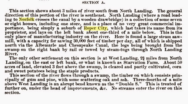
Ever heard of Roper City or Starvation Farm?
It was a sawmill community that existed between the present-day West Landing Marina on the north bank of the North Landing River and the Mount Pleasant drawbridge. The community provided lumber to Norfolk and Mr. Roper's shipyard company, The Norfolk Shipbuilding and Drydock Corp., which later became NorShipCo. It's noted on the map of the Norfolk, Albemarle and Atlantic Railroad that follows shortly. (See an expansion of this info in the following extract.)
The Norfolk, Albemarle and Atlantic Railroad.
It ran from Euclid, Virginia, to Munden Point from about 1890 until 1940. Its main use was to ship farm produce to Norfolk and to transport hunters going to the hunt clubs on Back Bay.
Euclid.
I'll bet most of you never have heard of this, either. It's a village midway between Norfolk and Virginia Beach, on the Norfolk Southern Railroad, near 36 degrees 50 minutes 25.00 seconds North latitude and 76 degrees 09 minutes 20.00 seconds West longitude, Princess Anne County, Virginia. The location is the area around Witchduck Road between I-264 and Virginia Beach Boulevard. It was the place where the line split and headed south to Munden Point. The other branch eventually continued to Virginia Beach, then north around Cape Henry, across Lynnhaven Inlet, and back to Norfolk.

I'm still looking for a topo map that shows the railroad's exact position from Euclid to Munden Point. I have heard there are still a few places where the roadbed is visible. From Euclid, it went straight to the Virginia Beach Courthouse (crossing between the junction of Princess Anne Road and North Landing Road and Holland Road), then went through the village of Pungo, crossing Indian River Road just before you get to the stoplight at Princess Anne Road. More photos and articles on the railroad are available on the Web.
Other interesting maps.

This sideways 1780s map of the county shows an island from Lynnhaven Inlet to Little Creek, as well as other neat stuff.

1864 - The Civil War Years. A military recon map showing rebel camps.

1907 - The rail loop to the beach is on this map.
Said Charlie in a closing email note to me, "Often have thought about doing a history blog--maybe when I'm too old to fish."
No comments:
Post a Comment